
Increase the Accuracy of GPS Linework
The algorithm used by Curvefit uses a Tangency Search Engine to create the most ideal series of Straight and Curved segments. When the linework being processed has been derived from a feature that was originally designed to include tangent segments (such as road centerlines) or from natural tangent features (such as stream centerlines), we can say that a refinement of GPS recorded points into linework with tangent segments is an increase in the accuracy.
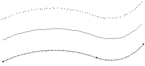
This example shows a group of points collected by a GPS system as the operator followed a road centerline. The linework created by this GPS data is shown to roughly follow the centerline with obvious inaccuracies caused by a number of factors (including the stability of the operator). The Curvefitted linework shown near the bottom represents the most likely centerline.
“We use Curvefit for dampening random GPS error recorded when we make dynamic measurements of approximate road centerlines. It is far superior to any curve fitting or splining program we have ever seen, in fact your algorithm actually increases the accuracy of these GPS derived polylines by averaging several measurements. Curvefit consistently reduces vertices by factors nearing one order of magnitude without degrading the accuracy of the measured line. The amount of data reduction and the increased accuracy is amazing”.
J.D. Mason, President
Analytic Geography,
Rapid City, SD