
GPSxform – Automated GPS Data Conversion
GPSxform automatically transforms GPS field data into standardized AutoCAD drawings according to detailed definitions. This operation replaces blocks generated by Pathfinder Office with project standard Gospel blocks and the attribute data can be passed from the GPS block to the new project standard block in any order.
User defined configuration files store a complete definition for each GPS point used in a given project. The definition includes replacement Block and Layer names as well as a Layer name for associated linework.
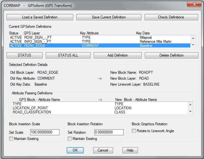
A project definition will usually include a definition for each item in the GPS Data Dictionary. This allows instant creation of drawings that conform to selected project standards from GPS field data.
Global Block Settings
Block Scale and Rotation can be set to a value or use the GPS block values. A special Rotate to Linework setting will process and GPS Block with embedded linework. If checked, this feature will rotate the graphics portion of these New Blocks to be aligned with the embedded linework.
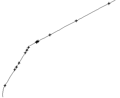
Here’s an example drawing as output by GPS Pathfinder
Transform GPS Field Data into Standardized AutoCAD Drawings
Trimble Pathfinder Office creates an AutoCAD file (DXF) where each GPS Data Dictionary item is used as the Layer Name and blocks are named arbitrarily (with a number). Therefore GPSXFORM was designed to process all blocks on a given GPS Layer and replace them with New Blocks from the Gospel_Blocks directory.
When GPSxform runs, blocks are redefined and all data is passed from the Trimble block to a user specified GOSPEL_BLOCK insertion and associated linework is reproduced on the specified layer.
Here’s the same drawing after processing by GPSXform
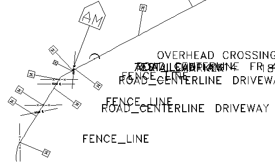
Notice that the Road Crossings and Fence Crossings have been rotated to the appropriate angle.
Save and Recall definitions
GPSXFORM performs its work based on definitions from a disk file. These definitions can be saved in and recalled from named definition files. Adding a GPS transform definition is accomplished using a dialog box interface.
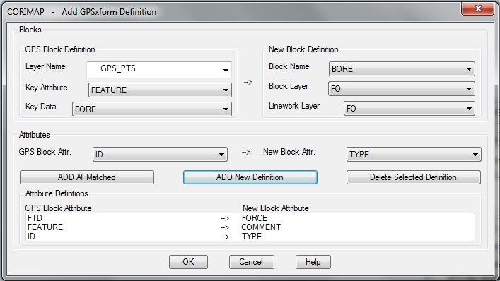
GPS Block Definitions can include all blocks on a given GPS Layer or only those that meet an Attribute test defined by an attribute name and/or and attribute value. This allows virtually unlimited selection capability. Once the GPS and New Block definitions are completed, the attribute passing specs are determined by picking attributes from pulldown lists.