
2D and 3D Stationing
Slope Stationing (True Distance)
CoriMap is unique among mapping systems with the introduction of 3D Stationing, also termed Slope Stationing. This capability measures true, 3D distances along the corridor baseline instead of the more common 2D or Horizontal Stationing. Slope Stationing will produce stations equal to those measured using a “wheel”. This means every feature in a map processed by CoriMap is referenced with a true distance station value.
Baseline Stationing
Baseline Stationing can be performed on 3D baseline polylines using either 2D (Horizontal) or 3D (Slope) Stationing. The format and number of decimal places are selectable as well as the Station Block name, scale and rotation angle.
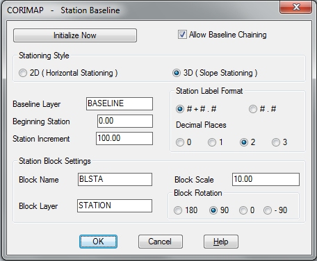
A Baseline can be one continuous 3D Polyline entity or a logical Baseline can be processed using any number of coincident 3D Polyline segments (Baseline Chaining).
CoriMap can station an entire corridor, made up of many drawings in batch mode, with the station values automatically carried forward. Multiple unconnected baseline segments in one drawing are automatically handled (where the corridor leaves a sheet and then returns at a different location).
Feature Block Stationing
Point Features collected in the field are represented by Attribute blocks. If these attribute blocks contain a Station attribute, the CoriMap™ Station Blocks tool can calculate and record it’s Slope Station (based on a perpendicular point along the baseline). If an Offset attribute is included in the feature block, the Offset Distance and Offset Direction will also be calculated and record.
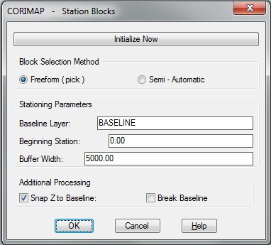
Special features:
Z-snap – the block Z is changed to match the baseline station point. This creates a ribbon depiction of the data (all blocks on the same Z plane as the baseline).
The Break Baseline feature will break the baseline at the station point for each block processed. Matchline blocks can be stationed and the baseline broken in one step.